Value Proposition
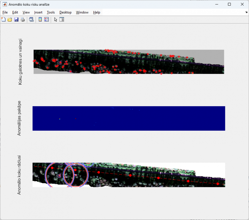
The developed software prototype enables automated detection of potentially hazardous trees near power lines using hyperspectral imagery and canopy height model (CHM) data. The system integrates spectral anomaly detection with tree height analysis to identify unhealthy trees that may threaten electrical infrastructure. The solution supports infrastructure monitoring by reducing manual inspection effort and enabling early identification of vegetation-related risks.
Business and Innovation Perspective
Challenge
Vegetation located near power lines represents a major risk to energy supply reliability. Traditional inspection methods are labor-intensive, expensive, and often unable to identify early-stage physiological stress in trees before visible damage occurs.
Existing Alternatives
Current monitoring approaches mainly rely on:
- visual inspections,
- LiDAR-based vegetation analysis,
- standard multispectral imagery.
These methods may fail to detect early physiological decline or require extensive manual interpretation.
EDI Solution and Uniqueness
The developed prototype combines:
- hyperspectral imagery (HS),
- canopy height model (CHM) data,
- AI-based anomaly detection methods.
The system identifies trees with anomalous spectral reflectance while simultaneously assessing their structural risk (tree height and proximity to power lines) without requiring labeled training data on tree health condition (unsupervised approach).
Key advantages:
- automated tree crown detection,
- tree-level anomaly analysis,
- integration of spectral and structural information,
- export of detected hazardous trees to GIS-compatible shapefiles.
Technology Readiness Level (TRL)
TRL 4–5 (technology validated in laboratory and relevant environment)
Intellectual Property Status
Research prototype / know-how
Projects
This prototype was developed within the NextGenerationEU-funded project “Methods, tools and techniques for smart development of energy system (MESVA)” as part of research activities related to UAV-based hyperspectral monitoring for power line infrastructure safety.
Technical Specification
Operating Principle
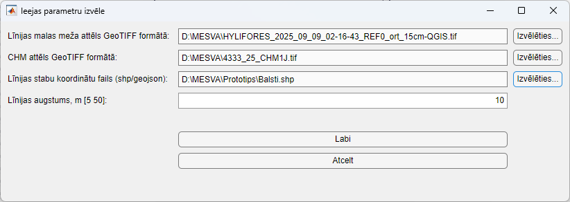
The software processes hyperspectral GeoTIFF imagery together with canopy height model (CHM) data and power line vector data. Tree crowns are automatically detected and analyzed using spectral anomaly metrics. Trees exceeding predefined anomaly and geometric risk (tree height and power grid proximity) criteria are classified as potentially hazardous.
Results are visualized interactively and exported as GIS-compatible shapefiles for further analysis.
Key technical parameters
| Parameter | Value / Description |
| Input data | Hyperspectral GeoTIFF, CHM GeoTIFF, vector file of power line poles |
| Operating system | Windows 11 or later |
| CPU requirements | 4 cores, 3 GHz |
| RAM | Minimum 16 GB |
| Disk space | Minimum 10 GB |
| Platform | MATLAB Runtime 2024b |
| Output | Visualization windows and GIS shapefile with detected hazardous trees |
| GIS compatibility | QGIS-compatible shapefile export |
Type of Cooperation
- Contract research and collaboration
- Joint development and adaptation for utility operators
- Potential future licensing of developed algorithms and software components