European Space Agency project
“Sentinel for confidence in outdated maps: SentiMap”
![]()
Contract No. 4000139312/22/NL/SC/rp
Scientific manager: Dr.sc.comp. Ints Mednieks
Project objective
To build a technology prototype for detection of outdated areas in aerial images and land cover maps using Sentinel satellite imagery or any other up-to-date imagery
We will develop two prototype workflows (software) for identifying outdated areas in VHR aerial imagery and land cover maps (our aim is to detect change confidence, not specific land cover class changes).
Both workflows will produce a raster map layer with the same spatial resolution as the up-to-date Sentinel or VHR aerial dataset showing algorithmic confidence that information corresponding to the specific pixel is outdated.
Project results
Within the framework of the project, software tools “SentiMap tools” were developed and handed over to cooperation partners (Latvian Geospatial Information Agency LĢIA) to support the preparation of topographic maps:
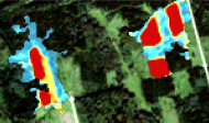
- Change detector in Sentinel-2 images
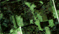
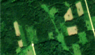
a) 2016 b) 2020 c) changes
- Detector of obsolete map areas from very high resolution (VHR) images
- Height change detection tool in surface models
LĢIA performed external validation of the developed tool in 40 test areas. A commercialization plan and recommendations for raising the TRL level of the software and introducing it into production were developed.
The project was successfully completed and the results were accepted in May 2024.
Participating scientists


Dr.sc.comp. Juris Siņica-Siņavskis
Software engineer