![]()
Project objective
The goal of the EO-BALP project is to develop a cloud service platform for earth observation data access and processing and provide six different applications that will demonstrate the practical use of satellite data in different domains:
- Monitoring application of infrastructure and settlements with more than 60,000 inhabitants, which will help to detect and characterize ground movements from satellite data, and to identify dangerous places in infrastructure protection zones
- A water quality monitoring application that will help determine water quality and pollution, as well as pollution sources in the Baltic Sea, coastal waters and inland waters
- A forest change monitoring application, which will help to regularly detect clear-cuts and wind falls, as well as forest damage caused by diseases, pests, fires, water, etc.) and will provide the latest satellite data mosaic service in all Baltic countries
- An agricultural land monitoring application that will help identify wildfires and flooded agriculture field areas
- Natural resource extraction monitoring application that will help identify illegal resource extraction sites (peat, sand, gravel, etc. mineral resources)
- A marine monitoring application that will help identify ships, their type, location and movement.
Project results
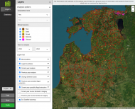
As part of the project, a classification workflow was developed and the classification of mineral resources in the Baltic States was carried out in 2023 and 2024. The NREM mineral resource monitoring service has been integrated into the Baltic States’ land observation platform GeoHUB:
The project was successfully completed and the results were accepted in June 2025.
Participating scientists