Project type: European Space Agency project
Contractor: Institute of Electronics and Computer Science (IECS)
Project number: 4000133163/2020/NL/CBi
Scientific manager: Dr.sc.comp. Ints Mednieks
Time frame: from April 1, 2021 to May 31, 2022
There are two overall objectives of the Dynland-2 project:
- to augment our self-learning land cover classification technology Dynland with capabilities to perform object based context aware classification
- evaluate the prototype software by doing a feasibility study to extract tree species information at microstand level from Sentinel 1 & Sentinel 2 in Latvia.
We will accomplish this by:
- doing a study into current state of the art in object segmentation methods
- doing a study into the state of the art in contextual information fusion
- implementing geomatics workflows and build new software prototypes modules.
These will augment our existing land cover classification technology and software Dynland.
As a result of this project, we will deliver a feasibility study, technical reports and web-accessible software prototype for unsupervised object based context aware land cover classification.
We will perform an internal and external evaluation of the technology with some of the currently interested parties in forestry management.
Project results
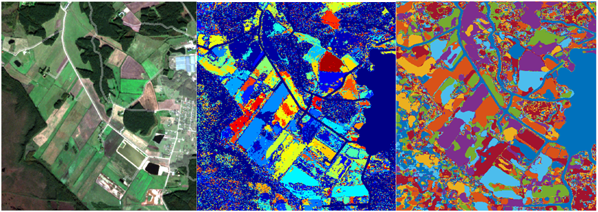
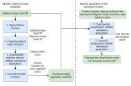
The main result of the project is the addition of object analysis-based capabilities (Dynland GEOBIA technology) to the Dynland classification technology, as illustrated below. The results were validated in collaboration with SIA Baltic Satellite Service by classifying tree species from Sentinel-2 satellite data in various regions of Latvia. An overall classification accuracy of 78% was achieved.
The project was successfully completed and the results were accepted in October 2022.
Participating scientists