European Space Agency project “Automated identification of mires and peatlands using multi-temporal satellite data” (MireClass)
Prime Contractor: Institute of Electronics and Computer Science (EDI)
Subcontractor: SIA “SWH SETS”
Project number: 4000128570/19/NL/SC
Scientific manager: Dr.sc.comp. Ints Mednieks
Scientific manager of the subcontractor: Dr.sc.comp. Ilze Bērziņa
MireClass project aims at creation of a Web application for monitoring and analysis of current state and dynamics of raised bogs and peatland inventory in an easy and convenient way using multispectral and Synthetic Aperture Radar data and unsupervised classification technology developed by EDI. The main objectives of the project are:
- Develop a methodology for automatic and semi-automatic identification of selected mire habitats and peatlands by classification of satellite data using WiseClust technology and integrated expert knowledge;
- Create specific tools for accurate automatic or semi-automatic classification of multi-temporal data into specialised subclasses of mires, which present interest to industry and public sector, using sample areas;
- Develop a Web application providing tools for classification of mires and peatlands and viewing the results;
- Create a reliable 20m^2 per pixel binary (present or absent) map of raised bogs and peatlands for the whole territory of Latvia.
Project results
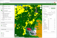
The MireGIS online application has been developed, which allows for the classification of bogs and peat extraction sites.
The project was successfully completed and the results were accepted in January 2023.
Participating scientists

Mg. math. Juris Breidaks
Former EDI researcher